Mapping connectivity in the Glasgow City Region to enable a thriving digital economy
Glasgow City Region is the fourth largest city region in the UK and Scotland's economic powerhouse. Glasgow City Region has a population of 1.84 million people, a population which is growing, and which is roughly one third of Scotland. Glasgow City Region is a collaboration of 8 local authorities with urban and rural environments with differing landscapes of fixed and mobile connectivity available. The Region, an area of 3,346 square kilometres, features extensive greenspace and many areas of natural outstanding beauty, a number of local towns and a sophisticated urban centre
What is the problem to be solved?
Digital technology is now a key part of most people's personal and work lives, as well as how we access services. The adoption of mobile connectivity in Smart Social Housing and Digital Health and Care services means that we must have ubiquitous and fit for purpose connectivity, including fibre, 4G, 5G and LoRaWAN. A lack of good mobile coverage information causes residents, businesses and councils to often procure the wrong mobile networks - damaging productivity. This can also be a costly mistake to switch for people as they generally need to pay 95% of the lifetime value of a contract to switch.
Our Region must be future proofed for any upcoming innovation within this new digital age to ensure a thriving digital economy.
We have accurate maps of current and planned fixed connectivity available to local authorities through the UK and Scottish Governments. However, the mobile data publicly available to local authorities is limited to forecasted coverage data direct from the mobile network operators. This data is often not an accurate measure of the real time coverage available to customers and does not include upload and download speeds, quality of the network or capacity of the network in high density areas. There is also no planned coverage data publicly available from mobile network operators.
What is the solution to the problem?
What we’re doing
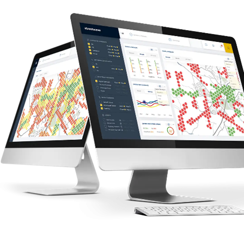
To understand the current mobile coverage and quality of the network, Glasgow City Region have commissioned an independent mobile mapping exercise with Commsworld and Streetwave. This work is being funded through the UK Government 5GIR programme called Smart and Connected Social Places.
The mobile network mapping will visualise data for every address within the City Region on an interactive map. It will show the strength of signal for all 4 Mobile Network Operators (MNOs), EE, Vodafone, VM02 and Three UK. It will answer practical questions like can I make a phone call? Can I send and receive email? Can I browse the internet? Can I work away from the office? Can I do HD Streaming? It will also include upload/download speeds and latency of the network.
Streetwave will undertake two on foot surveys in the Glasgow City Centre and around key stadiums within Glasgow City at peak times. This exercise will analyse the performance of the network in high density areas of the city during major events.
Commercial model (Business Case)
What will we do with the data
We will use the survey data to identify mobile and LoRaWAN ‘not spots’ across the region.
We will combine the coverage and asset data, fibre and potentially power datasets as these are also needed for any new deployments. The data will inform conversations direct with the MNOs and policy makers to address the not spots.
Glasgow City Council have a Telecoms Unit which engages directly with operators to encourage investment in connectivity and support investment through Council policies and processes. The Telecoms Unit will use this survey data in conversations with MNOS to address these not spots.
Survey data will be combined with Social Housing and Health and Social Care building asset data across the City Region. This will allow the programme to forecast where future network requirements will be in relation to the Smart and Connected Social Care Programme. We will share this data with MNOs to include in their future network plans.
Health and Social Care Services are critically important and require secure, stable and resilient connectivity. The advance of 5G Network Slicing is an option which could provide this level of mobile network service to Health and Social Care Services. This however will require ubiquitous 5G across the Glasgow City Region.


Benefits
How this will support our Smart Connected Social Places Programme
The 5GIR Smart and Connected Social Places Programme is focused on Social Housing and Health and Social Care. It is leveraging digital connectivity solutions to keep people safe, well, and socially connected in their own home and in their local communities. It aims to enable right-time and right-place interventions to promote wellness and prevent illness.
The programme is using IOT and mobile sensor technology in social housing to ensure a safe and healthy homes for residents. Housing providers will also be able to utilise the data insights to make better informed decisions around property maintenance and empty properties.
The programme is deploying Telecare connected Alexa devices in a trial that will see some of the biggest innovation in the Telecare Service for 30 years. The Alexa devices will make use of a home hub developed by CENSIS that requires 4G or 5G to connect to the alarm receiving centre (ARC). It is therefore important that we have good 4G or 5G Service for these devices.
Making the data we collect using the Streetwave devices publicly available will allow citizens, businesses, local authorities and Government to decide on the best mobile network for their needs. This could lead to boosted productivity for council employees working in the field, as the procurement teams can switch them to the best mobile networks in the areas they work in, Citizens could have a better connectivity experience by using the data to choose the best available mobile network in their area.

Lessons Learnt
Why did we choose this type of survey?
Before embarking on the mobile coverage mapping project with Commsworld and Streetwave, a number of channels were explored to obtain the mobile and LoRaWAN data for the Region.
OFCOM mobile availability checker was accessed in the first instance. However, results for 4G and 5G on their app are predictions and not a guarantee of service. The data also does not include any upload/ download speeds, quality of service or planned coverage.
Data direct from MNOs
Mobile Network operators were also approached directly for the information. This information is commercially sensitive for MNOs and therefore they are reluctant to share this data. Two MNOs were only willing to share the data under a non-disclosure agreement which restricted our use of the data. We would not be able to share this data with other organisations, SME’s or citizens. The data we received was predicted coverage data and some planned data. There was no upload/download speeds or quality of service data. Data compatible with GIS was also not available.
Crowd Sourced mobile data
Crowdsourced data is gathered from software developer kits that are hidden in the background of free to use mobile apps. The person who is using that app will (generally without their knowledge) give a signal reading for their network/location to the crowdsourced dataset. Crowdsourced data is relatively cheap to collect, and you can get data points across a wide area where people use these apps. Operators use this as part of their marketing efforts as they can make coverage claims across large regions such as the whole of the UK.
If you’re ready to embark on a connectivity project, we can point you to the suppliers with expertise in your sector.
