Image courtesy of ITS UK
What is the problem to be solved?
This toolkit covers smart traffic management and traffic signals and considers the wider traffic management across all roads in the UK and the application of a comprehensive Traffic management “system” beyond traffic signals and signs. The advisory toolkit considers the availability of data from a wider set of sources enabled by robust 5G connectivity.
Local Authorities managing roads implement measures to control and manage traffic, using connected technology to minimize congestion and improve safety. Smart traffic management systems integrate sensors, cameras, real-time data, and connected devices, which are mainly infrastructure based, to monitor traffic conditions, types of traffic and detect congestion. Informed decisions can then be made to control and manage traffic.
Traffic management involves the control of traffic flow in towns and cities to keep them moving efficiently, using regulation, enforcement and optimisation. Ineffective traffic management results in compromised road safety and congestion with knock on impact on journey times to car, transport and logistics operators.
What is the solution to the problem?
An Intelligent Traffic management system integrates various technologies to manage the road network. These components work together to create a cohesive system that enhances traffic management, reduces congestion, and improves road safety and include:
Hardware
- Sensors: cameras, radar, inductive loops that collect data on traffic flow, speed & vehicle types.
- Digital Signs: Variable Message Signs (VMS) and Vehicle-Activated Signs (VAS) provide real-time information to drivers.
- Traffic Signals: Adaptive traffic signals adjust timings based on real-time traffic conditions.
Software
- Traffic Management Software: Manages traffic flow, incident detection, and response.
- Data Analytics: Analyzes traffic data to optimize traffic management strategies.
- Control Systems: Software integrating various ITS components and manages operations.
- User Interfaces: Applications and dashboards to monitor and control the system.
Connectivity
- Communication Networks: Fibre, Wi-Fi, and cellular networks.
- Protocols: Standard communication protocols to ensure device and system interoperability.
- Cloud Services: Data storage, processing, and analytics.
Traffic Control Centres (local and regional)
- Servers: High-performance servers that process and store large volumes of data.
- Displays & workstations: Provide a comprehensive view of the traffic network.
- Backup Systems: Redundant systems to ensure continuous operation in case of failures.
The need for ubiquitous and robust 5G across the road network to enable this capability is covered in the ROADS connectivity advisory toolkit.
While conventional traffic management systems include roadside equipment providing information to traffic control centres, a growing number of other inputs are available from devices and vehicles. AI is also providing the ability to refine the data at source or in the cloud to enable more insights to be developed.
Smart phones that travellers carry with them and have in their vehicle can be used as sources of information/data and their displays used to relay advice and information to a driver.
The Co-operative Intelligent Transport systems (C-ITS) platform now have a significant body of standards and technical specifications covering traffic management systems. Standardisation and recommendations for the future are outlined in DfT’s data strategy document from 2023 Transport Data Strategy.
There is a big opportunity to improve road safety and traffic management and road efficiency using shared vehicle data. Vehicle data shared with road users and operators will locate hazards from roadworks and debris to stationary cars and traffic. Vehicle data can also help to share local environmental issues such as ice, flooding and accidents where an airbag has been deployed (accessed through e-call). Modern vehicles are lots of useful data as they move around the transport system. Vehicle data can be assimilated via a data platform and then shared using location relevant messaging to in-vehicle devices (installed or mobile).
It is expected that the UK will remain aligned with European regulations and standards regarding V2X (vehicle to everything), wireless communication between the vehicle and any other entity the vehicle may interact with. In Europe ETSI are leading the development of data standards for the application of these technologies to C-ITS which are termed C-V2X (cooperative vehicle to everything).
5GAA (5G Automotive Association) is a consortium representing the mobile telecoms, technology and motor industries (setup in 2016) and has been working on solutions for “future mobility and transportation” focussed on C-V2X.
Europe designated 5855-5875MHz and 5875-5925MHz for use by road ITS in 2023 with a neutral technology assumption. China, USA Korea and India have defined C-V2X spectrum, with China leading the rollout; 20 cities are now designated for implementation of C-V2X in 2026.
In the UK, DfT have been working to standardise various road data to make it discoverable and enable sharing. This will help road authorities operate more efficiently and share the data to others. This allows new technologies to be developed from accessible data sets. Some key initiatives underway include:
- “National Parking Platform” (NPP), National Parking Platform will provide a single parking interface for drivers and parking operators.
- “Street Manager” for roadworks, data associated with roadworks Street Manager.
- Traffic Management System (National Highways) sharing planned works, delays or congestion data. Enables road condition modelling, regional traffic coordination and journey planning. (Digital Roads - National Highways, Technology Strategy 2035)
The Netherlands started a comprehensive initiative in 2016 to introduce a transport and traffic platform called “Talking Traffic”. Existing traffic signals have been converted to be intelligent and “connected”, with the ability to exchange data with smartphones and satellite navigation systems. Data sharing standards have been created so information is presented in the same format allowing a single interface
for the user, which works across regions. This enables road operators to buy hardware from one supplier and products from other suppliers, supporting innovation and business. The heart of this platform is the Urban Data Access Platform (UDAP) which provides a fast and reliable data exchange ( Technology behind Talking Traffic ).
5GSA (Stand Alone) which has higher mobile comms speed and data throughput is starting rollout in the UK through the Telecoms Network Operators. Edge computing will also be available where needed, which provides faster data throughput and processing and cloud-based services allowing widescale sharing of outcomes complete the key ingredients for future intelligent traffic management. These are the transformative enablers which automotive and the traffic operators need to deliver the services described.
Initiatives underway and recommendations:
- It is important that road authorities and service providers should make high-quality data available in standard format that is easy for service providers to access supporting products and services and encouraging innovation. Ensure published standards are used for interfaces wherever possible to maximise the potential for integration and consumption of the published data building on the DfT data strategy.
- Review the data and the data platform needed to fully cover parking, roadworks, traffic, traffic signals, vehicle data associated with road conditions and safety. This study should consider the comprehensive set of data required from the road network to characterise the infrastructure and road users. This builds on initiatives already started as listed above. A full list of data required to enable the future intelligent traffic management system will enable a gap analysis to compare data already available vs that required. A roadmap can then be provided to align with the Integrated National Transport System (INTS) being developed. Assessing this against the requirements of the ITS directive will provide alignment with Europe. This task although led by DfT should include DSIT.
- Provide support for providers to trial new services enabled by the data described above. To continue to develop capabilities in real-world environments and provide a supportive environment for business and highways authorities to develop together. This may be a region and city in the UK. This region should align with that suggested in the ROADS connectivity advisory toolkit where ubiquitous and robust connectivity is available.
Collating the extended data sets from vehicles and other devices and using AI to analyse and adapt to traffic and road situations offer improvements not currently possible in fixed traffic assets and fixed control regimes. Using AI to intelligently control traffic and inform drivers should be closely aligned to the AI initiatives and investment recently proposed by central government.
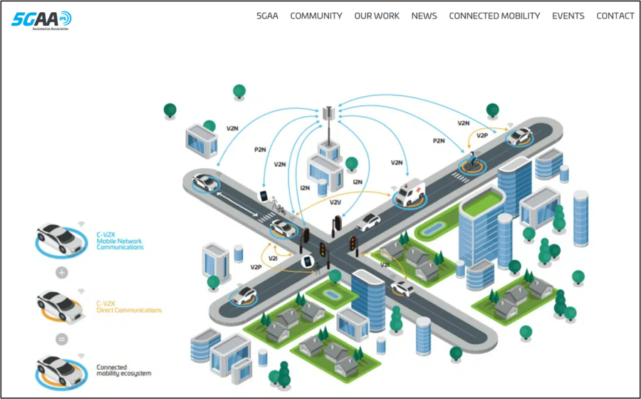
Image courtesy of 5GAA
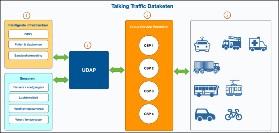
Netherlands “Talking Traffic” courtesy of DMI (Dutch Metropolitan Innovations)
Commercial model (Business Case)
Roads are the most used form of getting from one place to another for passengers in GB as shown below (How much people travel in Great Britain):
- in 2023, people travelled a total of 799 billion passenger kilometres
- 90% of all passenger kilometres travelled were by road (car, bus, active travel)
A summary of the extent of the road network and who is responsible for operating it in the UK, is shown below:
Road network in UK – key statistics
- 245,700 miles of public roads (Road Lengths in Great Britain: 2020 - GOV.UK)
- Most roads (by length) are managed by local highway authorities. These include principal roads, all minor roads (‘B’, ‘C’ and ‘U’ roads) plus some major roads.
9,500 miles of strategic road network (SRN, made up of motorway and trunk A roads)
Road Authorities in UK - operators
- 153 local authorities in England, 32 in Scotland, 22 Wales, 11 N Ireland (road operators)
- 11 combined authorities (road management oversight and some transport operations) England
- 4 Strategic Road Network operators, National Highways in England, the Welsh Government in Wales and Transport Scotland in Scotland. In Northern Ireland there is the Regional Transport Strategic Network (RTSN) managed by the Department of Infrastructure.
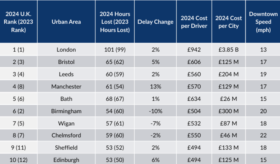
The impact of congestion and traffic control measures are illustrated below:
Congestion, traffic flow & safety
- London has the longest traffic delays in Europe of 101 hours lost per road user (£942 per driver), with the cost of congestion in the UK worth £7.7bn (£581 per driver), according to INRIX (2024 Global Traffic Scorecard).
- “A huge proliferation in traffic regulations over the past twenty years has imposed a heavy burden on the economy. Just a two-minute delay to every car journey equates to a loss of approximately £16 billion every year, equivalent to almost 1 per cent of GDP.” Institute of Economic Affairs.
Over 50% of road deaths and serious injury in the UK happen at junctions ( 2023, Road safety statistics: data tables - GOV.UK, RAS0503).
Costs to freight & logistics
Over 60% of road freight travels on motorways and trunk roads and tends to cover all times of day and night. In urban areas with peak freight deliveries frequently occurring in the morning, this impacts congestion Future-of-Freight. According to WSP’s 2018 study congestion was estimated to cost the freight industry £3.7billion annually.
- Road Haulage Association (RHA) estimates it costs a haulier £130 per hour per vehicle that is stationery in traffic (The Future of Roads Report - RHA). “Congestion accounts for 16% of the current cost of running an HGV due to lost productivity. It is estimated that 35% of HGVs trips will be delayed in 2050 without mitigation”.
- Queues to ports and especially Dover have been a regular occurrence with the A20 and M20 being used as a lorry holding park many times (Dover: Council will declare 'major incident' if travel disruption persists - BBC News).
- Connectivity enabled route planning, navigation and delivery optimisation reduces empty return runs and avoids HGV inappropriate routes being selected.
Traffic signals
- There are an estimated 33,000 traffic signals in UK (actual numbers unclear but rising).
- Intelligence in traffic signals reduces traffic delays. They can operate at individual junctions (e.g. MOVA) or at a series of junctions and can respond to changing traffic conditions (e.g. SCOOT) resulting in improvements of ~15% (SCOOT® - TRL).
Green Light Optimal Speed Advisory (GLOSA) has been shown to offer improvements in journey time as well as fuel consumption (Interregeurope)
Active Traffic Management (ATM) systems on motorways using roadside and gantry signs
- Congestion management using variable speed limits to smooth traffic flow and reduce the likelihood of sudden braking and acceleration.
- Lane management to open or close lanes including the hard shoulder
- Incident management providing information to drivers and emergency services, to clear accidents more quickly and reduce congestion.
- Work zone safety improve by lowering speed limits in work zones.
The Department for Transport is forecasting up to a 55 per cent increase in traffic by 2040 and up to 85 per cent increase in congestion levels (Congestion-report_LocalGovtAssoc).
The impact that traffic management systems have is significant. Advances in devices, connectivity and data provides the opportunity to enhance the vehicle or driver decision making in congestion mitigation and improving safety through the use of Intelligent Traffic management systems of the future.
The ability to provide road hazard and status information via mobile communications to connected cars and devices in rural and urban environments will significantly improve convenience and safety in a way not otherwise affordable. National Highways for example, spends £10’s of thousands on each gantry for information and traffic management systems, this is not affordable at scale on the rest of the road network.
The Netherlands “Talking Traffic” platform is using intelligent traffic signals, information shared via the smartphone or built-in navigation, via an urban Data Access Platform (UDAP) and is using existing mobile telecoms. The cost benefit is cited below from DMI (Dutch Metropolitan Innovations):
““An important development within Talking Traffic is that road users not only communicate with each other, but also with the infrastructure. And that with a delay of a maximum of one second. Within Talking Traffic, intelligent traffic control systems (iVRIs) know which cars, cyclists and buses are approaching them. This makes it possible to coordinate traffic flows more efficiently with dynamic traffic light controls. iVRIs can also 'prioritize' and give certain traffic flows priority, i.e. green light earlier or longer, over others. It saves braking and acceleration and therefore time, fuel and CO2 emissions, as well as money. It has been calculated that there is an annual social cost of €90 million because not all traffic lights are adjusted often enough. With new iVRIs, this is done continuously and automatically. Thus, the investment quickly pays for itself.”
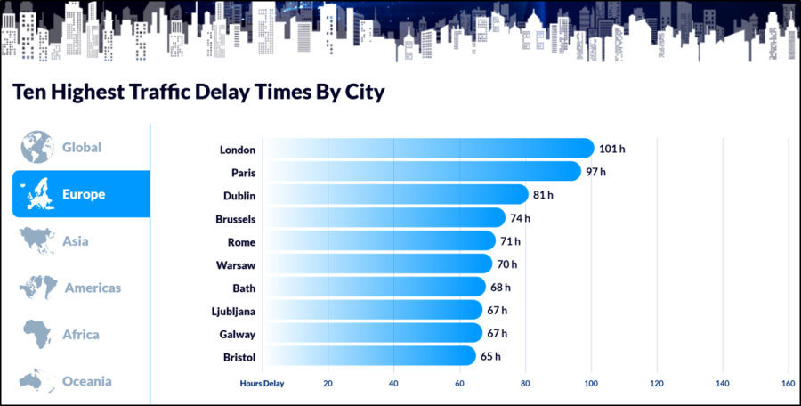
Images & data courtesy of INRIX (2024 Global traffic scorecard)
Benefits
Intelligent traffic management using a wider source of traffic and road user input data (sensors and vehicle data), collated and shared with traffic signals and other road users can offer the following benefits:
Qualitative Benefits
- Road safety and security
- Productivity due to predictable travel/commute time
- Traffic Management system efficiency
- Road user experience
Quantitative Benefits
- Traffic delay management for private and public transport (also reduces the pollution)
- Journey time reliability for all transport modes
- Improved road safety, reduction of traffic accidents
- Reduced road traffic collisions response time and recovery time
- Reduced operational costs through renewals or new technologies
- Goods delivery systems implementation reducing delays for service and goods delivery vehicles
- Reduction in air pollution and noise
- Improved road management and traffic flow prediction
- Optimised freight operations
Shared sensor data, wider use of alternative forms of traffic data and integrated traffic and roadside systems can potentially achieve much wider benefits.
- Traffic monitoring for congestion control also provides input to digital twins so the use of roads junctions can be characterised, road user behaviour modelled and insights in to journeys across the road network understood e.g. Vivacity AI cameras. This modelling helps manage traffic, establish safety improvements, plan future roads and active travel lanes, knowing how people and traffic will behave and interact.
Intelligent and dynamic roadside bay reservations allow freight and parcel delivery while also making better availability of kerb parking and enabling taxi and autonomous car pickup/drop offs in the future. This also ensures consistent implementation of kerbside regulations. These joined up services using a common set of sensors result in better air quality, safety, support for urban pedestrianisation and reduction in vehicles looking for parking, lowering congestion.
The Netherlands “Talking Traffic” which is a large scale intelligent traffic management system is described by DMI as providing :
- Smarter use of mobility, travel times can be further reduced and traffic flow improved.
- Savings in travel time, fuel and costs contribute to the congestion relief and sustainability.
- Extra comfort on the road as you always know where you stand.
- Improving road safety through early warning, keeps attention on traffic and making the right choices at times that matter.
Further benefits are defined in the Executive summary ( Executive-Summary-NGF-proposal-dec-2022)
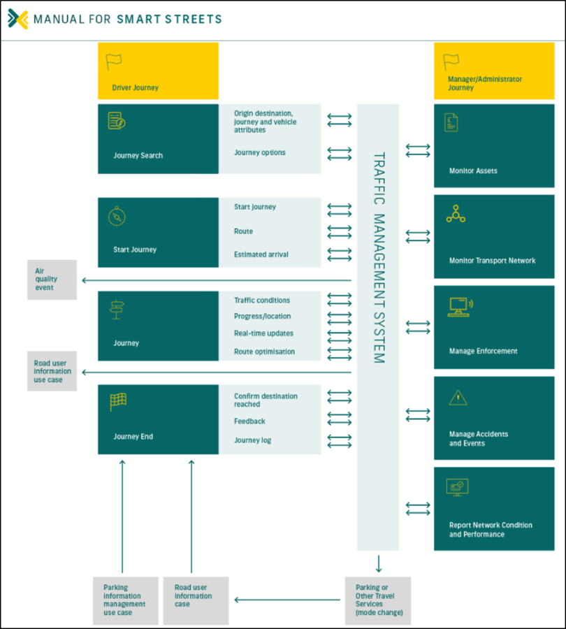
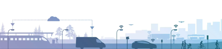
Image courtesy of Manual For Smart Streets Traffic Management - TTF
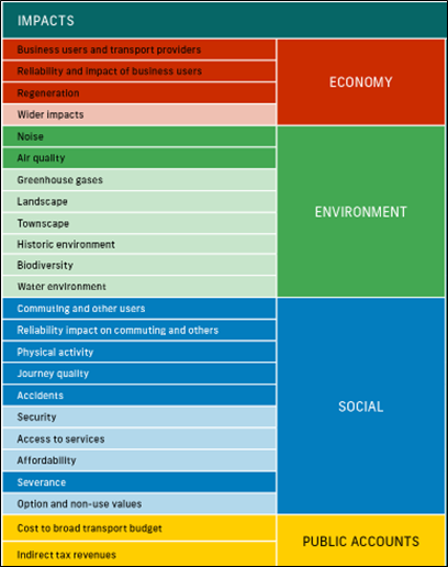
Image courtesy “Manual For Smart Streets”
Lessons Learnt
There are a number of organisation types working in the smart traffic management ecosystem:
- Sensor providers
- Traffic management software and system companies
- GPS system providers
- Data centre (cloud services) providers
- Mobile companies (mobile data, digital footprint information)
- Car manufacturers
If you’re ready to embark on a connectivity project, we can point you to the suppliers with expertise in your sector.