Image
road

What is the problem to be solved?

To benefit from the growth in digital and connectivity across the UK, the transport network requires a reliable level of service. Public Transport operators, private vehicle owners and freight operators will all benefit from pervasive and robust connectivity across the road network to improve the road infra structure and vehicle efficiency and safety of operation through a variety of digital products and services, many already available.
Connectivity across urban & rural roads and the Strategic Road network (SRN, major roads such as motorways) will improve road safety through connected and cooperative driving. 

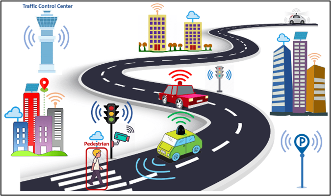
Connected vehicle driving involves vehicles that can communicate with each other (V2V), with infrastructure (V2I), and with other entities (V2X) using wireless technology. The main goal is to share information such as traffic conditions, road hazards, and vehicle status to improve safety and efficiency. Examples include real-time traffic updates, navigation assistance, and alerts about nearby vehicles or obstacles. 

To benefit from the growth in digital and connectivity across the UK, the transport network requires a reliable level of service. Public Transport operators, private vehicle owners and freight operators will all benefit from pervasive and robust connectivity across the road network to improve the road infra structure and vehicle efficiency and safety of operation through a variety of digital products and services, many already available.

Connectivity across urban & rural roads and the Strategic Road network (SRN, major roads such as motorways) will improve road safety through connected and cooperative driving. 

Connected vehicle driving involves vehicles that can communicate with each other (V2V), with infrastructure (V2I), and with other entities (V2X) using wireless technology. The main goal is to share information such as traffic conditions, road hazards, and vehicle status to improve safety and efficiency. Examples include real-time traffic updates, navigation assistance, and alerts about nearby vehicles or obstacles. 

Cooperative vehicle driving takes connected driving a step further by enabling vehicles to work together in a coordinated manner. This involves not just sharing information but also making joint decisions and executing coordinated actions. The aim is to enhance traffic flow, reduce congestion, and improve safety through synchronized manoeuvres and collaborative driving. Examples include coordinated lane changes, platooning (where vehicles travel closely together at high speeds), and cooperative merging at intersections. Cooperative driving is particularly important for the operation of self-driving vehicles in urban environments, where the density of vehicles, variety of junctions and mixture of cars, goods vehicles, scooters and bikes provides significant challenges to their operation. 

Passengers want choice in their travel time to be productive in work or engage with social and leisure activities, but this relies on data and connectivity. The demand for digital applications and data will grow, as more highly automated cars become available and drivers are free from the driving task. It is important for future proofing of connectivity provision that the Passenger demand is considered, as defined by the 2023 Wireless Infrastructure Strategy….”ensuring that digital connectivity requirements for future users of infrastructure are at the heart of major infrastructure projects”.

Freight tracking, optimised routing and integrating modes of transport to efficiently move goods and people across the UK all require robust connectivity. Vehicle monitoring, goods monitoring, remote check-in and advising the driver of hazards and optimal routing are in demand.

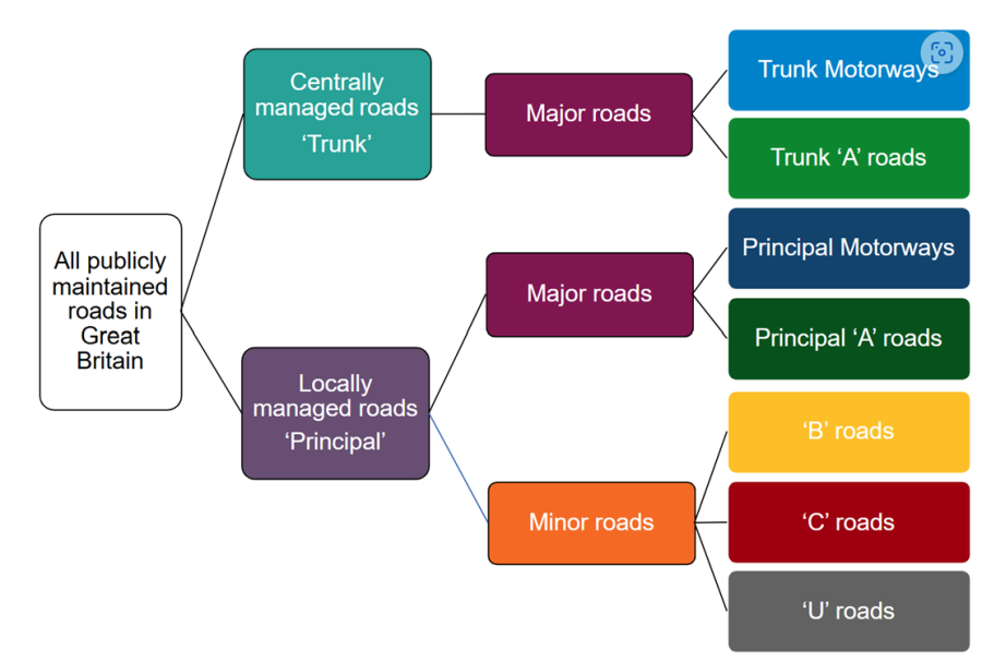
In Great Britain there are 245,700 miles of public roads. By length, most roads in Great Britain are managed locally (by a local highway authority or Transport for London). These are principal roads and they include all minor roads (‘B’, ‘C’ and ‘U’ roads), and some major roads (principal ‘A’ roads and principal motorways).
The rest of the major road network (trunk motorways and trunk ‘A’ roads) is managed centrally by National Highways (formerly Highways England) in England, the Welsh Government in Wales, and Transport Scotland in Scotland. The trunk road network in England makes up the Strategic Road Network (SRN).
Government owned assets are under pressure with real terms spending cuts and operational efficiency improvements required to transform statutory services. Local authorities (LAs) have several statutory responsibilities when it comes to maintaining and operating roads and transport. The key responsibilities for maintaining a safe and efficient transport network are:
 

  1. Road Maintenance and Management: Local Authorities are responsible for the upkeep and management of all roads within their jurisdiction including regular maintenance, repairs, and ensuring road safety.
  2.    Traffic Management: They must manage traffic flow, which involves implementing traffic control measures, managing congestion, and ensuring the smooth operation of transport systems.
  3.  Safety Regulations: Ensuring the safety of road users is a critical responsibility. This includes implementing safety measures, conducting regular inspections, and addressing any hazards.
  4. Planning and Development: planning and construction of new road projects must meet safety and environmental standards.
  5. Asset Management: Managing the assets related to roads and transport, such as signage, lighting, and road surfaces.

Monitoring and managing such a large road network is expensive and time consuming with highly utilised major roads and dense traffic in urban environments presenting challenges to operate efficiently and maintain. Similarly, less utilised minor roads also need to be safe to support all road users.
Innovation and adoption of new digital products to support Transport is limited and will result in the UK lagging in innovation, product development and business growth.
 

Image
road2

(GOV.UK  Road lengths in Great Britain 2023)


What is the solution to the problem?

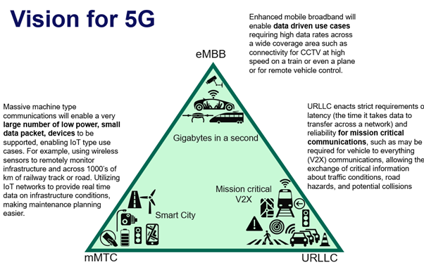
5G provides the ability to support high data rate devices (such as cameras), a large number of low data rate IoT devices (typically used for monitoring) and the provision of reliable low latency communications. A 5G stand-alone (5GSA) network can divide up the useable frequency range into separate dedicated bandwidths to support critical communications.

A 5GSA network can split frequency bandwidths (Network Slicing) to dedicate a slice to support small data packets from millions of connected devices (e.g. sensors monitoring infrastructure), while simultaneously providing another slice for safety critical services to support self-driving vehicles for cooperative junction management for example. 

There are currently no 5GSA networks available on the road network in the UK. The implementation of a 5GSA network on a selection of the road network would allow the demonstration of several new use cases for ITS (Intelligent Transportation Systems) and could be implemented using the radio frequencies of shared spectrum or mobile network operators reusing assets that already exist.

5G provides the ability to support high data rate devices (such as cameras), a large number of low data rate IoT devices (typically used for monitoring) and the provision of reliable low latency communications. A 5G stand-alone (5GSA) network can divide up the useable frequency range into separate dedicated bandwidths to support critical communications.

A 5GSA network can split frequency bandwidths (Network Slicing) to dedicate a slice to support small data packets from millions of connected devices (e.g. sensors monitoring infrastructure), while simultaneously providing another slice for safety critical services to support self-driving vehicles for cooperative junction management for example.  

There are currently no 5GSA networks available on the road network in the UK. The implementation of a 5GSA network on a selection of the road network would allow the demonstration of several new use cases for ITS (Intelligent Transportation Systems) and could be implemented using the radio frequencies of shared spectrum or mobile network operators reusing assets that already exist.

The Strategic Road Network can utilise (dark / unused) fibre deployed across the Motorways network to provide the backbone for data transfer. In addition, a number of SRN infra structure assets already in place can provide the secure height attachment and power supply for 5G Small Cells at the roadside. 5G masts and 5G Small Cells will fill coverage gaps and provide the ubiquitous connectivity needed.  

Urban roads in larger towns and cities are being upgraded to 5G but localised dropouts remain commonplace. Small Cells deployed in these “not spots” will provide both the device connections volume, capacity data availability and connectivity required. Utilising 5G open licences recommended by DSIT / DCMS and working with local authorities should overcome difficulties in accessing suitable locations for masts and small cells. There are a variety of suppliers of 5G Small Cells and 5G Tower providers in the UK who support the 4 main Telecoms providers who are VMO2, Vodafone, Three and BT/EE.

Rural connectivity is more challenging due to the lack of infrastructure including fibre and often power supplies can also be difficult. Various solutions are being trialled across the UK, sponsored by DSIT.

However, the details and locations of poor connectivity is not known across the whole of the road network in the UK and the performance of the connectivity and connections during a week or year is also not well understood. Authorities and road operators also have little information on the backhaul capability to support the data load and speeds required.

Several next steps are listed below with potential lead government organisations identified to lead a collaborative dialogue to develop each initiative:

  • TECHNICAL STANDARDS: Collate, agree or develop where needed, to define robust and available coverage required to support connected and self-driving vehicles. A collaboration with Ertico and 5GAA makes sense as both organisations are working on the details of connectivity and use cases required to support self-driving and connected vehicles in Europe. Other standards and organisations should be considered to maximise work already done across various groups.  DSIT & DfT should lead this initiative.
  • Establish the connectivity CURRENTLY AVAILABLE ON THE UK ROAD NETWORK: signal strength, latency, frequencies used, availability, backhaul capability and robustness across the entire road network in the UK. A proposal is required to establish a methodology, appropriate metrics and how this survey should be done. DfT & DSIT should lead this initiative. 
  • DEVELOP A PROPOSAL FOR ROBUST & RESILIENT MOBILE COMMUNICATIONS  ACROSS THE WHOLE strategic road network (SRN): using 5G small cells utilising the fibre available, connecting the fibre across the whole SRN. Implementation should include looking at the commercial investment model and pricing for services using already existing infra structure. DSIT and Strategic Road Operators (e.g. National Highways) should lead this initiative.
  • ESTABLISH LICENCES & SPECTRUM FOR SAFETY CRITICAL OPERATIONS: Can shared licences be used to provide connectivity through small cells and mobile connectivity services across the road network. This will enable a wider supply base to engage with affordable bandwidth. It may be possible to dedicate specific spectrum dedicated for certain applications. DSIT should lead this initiative with support by other interested parties.
  • Establish a UK pilot region: Establish a commercial grade 5GSA network and assess network slicing capabilities and alternative 5G high speed assured communications, to support CAV and Transport. This should include an urban area (city or large town) and section of the SRN, with a substantial real-world footprint. Consideration of routes and regions such as Kent and the M20 arterial to Dover, a key freight route, the Midlands plus the North East region (e.g. Newcastle & Tyneside) may provide suitable real world roads and traffic conditions. This could align with established testbeds for CAV such as QE2, Oxford and Midlands Future Mobility, already established through Zenzic and CCAV. This will need bandwidth and funding with a collaboration including invitations to all MNO’s, transport operators and Vehicle Manufacturers to participate and create a supportive and vibrant test and development site. DfT should lead this initiative.
Image
road3


Commercial model (Business Case)

The business case and the market opportunity for investment in robust connectivity to support the extensive UK road network is driven by the efficiency and safety improvements possible as a result of devices and vehicles always being connected. 

The business case and the market opportunity for investment in robust connectivity to support the extensive UK road network is driven by the efficiency and safety improvements possible as a result of devices and vehicles always being connected. 

The costs to operate and maintain the roads in 23-24FY was ~£2.1bn by LA’s, with a further £8bn provided by DfT for road condition upgrade (National Audit Office report, July 2024). Key findings from this report included:

  • There are currently significant gaps in DfT’s information on the condition of local roads, limiting its understanding of condition of the network. 
  • DfT does not consider the condition of roads or the factors that contribute to road deterioration when allocating funding to local authorities.
  • DfT needs to plan now for how it will support local authorities to meet challenges on the road network, such as climate change and the introduction of self-driving vehicles.

The importance of roads carrying people and goods across Great Britain. The number of freight miles and passenger miles travelling shows how much time is spent using the road networks. Digital products support improved freight efficiency, and improves the time spent by people travelling by offering greater choice of work or leisure activity. Data illustrating this importance is shown below from DfT (GOV.UK, 2023)

  • There are 2,300 miles of Motorway, 29,500 miles of A roads and 213,800 miles of minor roads in the Great Britain. The Motorways and A roads combined road length of 31,800 miles represents 13% roads by length in GB but handle >60% of road traffic. These major roads should be the immediate priority for connectivity.
  • Freight carried by HGV’s (vehicles over 3.5 tonnes) included 19 billion Km travelled, with 1.55 billion tonnes moved over a variety of product types, including 219 tonnes was food, 231 tonnes of quarrying materials, 193 tonnes of waste and 393 tonnes of “groupage” (mixed materials).
  • Parcels around 4 billion per year average 2021-2023 were delivered on UK roads (Statistica).
  • The amount of time spent by people travelling across modes of transport was 324 hours (53 mins/day) with 78% of miles travelled were in a car (National Travel Survey England, 2022). With the average car and van occupancy in the UK at approximately 1.6 people per vehicle1 , when fully self-driving cars are available the free time of occupants will more than double.

The maintenance and operational task to run an effective road network involves many government and commercial bodies. Casualties on the road remains a concern with improving but relatively high casualty numbers. Maintaining the infra structure on the roads such as traffic lights, road markings, street signs and other road “furniture” have statutory but irregular inspections, these can all be better and continuously managed with Digital products. Safety and maintenance statistics sourced from DfT (GOV.UK, 2023)

  • There were 1645 people killed, 27,998 seriously injured, with total casualties 132,063 (DfT reported road casualties in GB, 2023). Road fatalities by user type included 749 in cars, 306 motorcyclists, 84 pedal cyclists, 407 pedestrians. 
  • In 2023, the RAC attended nearly 30,000 pothole-related breakdowns1. Common issues included broken suspension components and damaged wheels with injuries to Cyclists and other vulnerable road users a significant concern. 
  • There are approximately 6.5 million lamp posts in the UK (Shropshire.Gov) with ~95,000 in Birmingham as a city example. These must be inspected and maintained but also provide an opportunity for being upgraded to be “smart”, hosting digital street signs, comms equipment and EV charging.
  • The road and roadside have multiple “assets” which must be monitored and maintained with road surfaces, road markings, signs, railings, vehicle restraints/barriers, kerbs, bridges, tunnels, traffic lights as significant examples.

Connected and self-driving cars, will provide more convenient and safer road travel in the future. These vehicles will rely on good connectivity to deal with the densely populated road network.

  • Self-driving cars will improve road safety as 78% of accidents in the UK are due to driver distraction from secondary tasks (ROSPA, Dec 2023). Early self-driving cars (hands off driving) will perform as well as competent drivers, with automated systems quickly improving as the systems learn from any error states. 
  • The UK is expected to see significant growth in self-driving vehicles with projections of 40% of sales by 2035 (GOV.UK “cusp of transport revolution”) for highly self-driving cars.
  • Connected and cooperative vehicles will be able to travel more closely together with the distance between vehicles significantly reducing as vehicle separation reduces from 2-3 seconds “reaction time” to less than 1 second or less (CCAV trials, UK Autodrive, Venturer and HumanDrive projects). This will increase the road capacity especially for major roads and the SRN and reduce road widening required as traffic increases. It cost ~£70m/mile for the A12 widening scheme and £16m/mile for the M1 Smart motorway widening between junctions 13-16 (National Highways). 

Investment in connectivity and infra structure investment is complicated and expensive. The costs & benefits require data and in-depth study and a government/commercial partner arrangement to setup and run the connectivity suitable to support the roads and transport operators requires consultation. Setting up a trial location with the key stakeholders involved will crystallise the business case and commercial model. This supports the UK government commitment in the wireless infrastructure strategy 2023, to digital connectivity requirements for future users of infrastructure being at the heart of major infrastructure projects.


Benefits

Digital products enabled by available and robust connectivity on the roads make a difference to the efficiency, safety, wellbeing, de-carbonisation, comfort & convenience of transport and pollution. These digital products enabled by robust IoT and 4G/5G networks across various environments are driving efficiency, cost savings and service improvements in both public and private sectors.

Digital products enabled by available and robust connectivity on the roads make a difference to the efficiency, safety, wellbeing, de-carbonisation, comfort & convenience of transport and pollution. These digital products enabled by robust IoT and 4G/5G networks across various environments are driving efficiency, cost savings and service improvements in both public and private sectors.

Digital products that support vehicles and road users can be clustered into the following descriptive groupings with many of the “monitoring products” focussing on real time tracking resulting in preventative actions to avoid larger more significant issues in the future:

  • Infrastructure & assets monitoring and management
    • Road infrastructure maintenance monitor of the road surface, markings and roadside hardware such as lamp posts, traffic lights, road signs etc.
    • Road environment monitoring including emissions, weather, ice and flooding.
    • Road traffic monitoring counts/vehicle type, user behaviour (informing investments and future road marking) and stopped vehicles.
    • Smart Traffic Management systems that use real-time data to optimize traffic flow, reduce congestion and maximise the Infra structure.
    • Smart Parking solutions with systems that guide drivers to available parking, reducing search time and hence emissions.
  • Self-driving cars: convenience of travel without the driving task. With on demand self-driving taxis being added to more traditional transport, the availability and accessibility of transport will improve. The ability for passengers to access convenient and supportive joined up transport will allow a broader range of people (including old and young) passengers to be able to travel. 
  • Safer driving for driver controlled and self-driving vehicles will be supported by safety critical functionality (ITS) for connected and cooperative driving with more complex functionality introduced in stages:
    • V2X day 1 – “Awareness driving”, V2V (vehicle to vehicle) road hazard information and emergency vehicles warnings.
    • V2X day 2 – “Sensing driving”, V2I (vehicle to infra structure) information passed from traffic centres via infrastructure to vehicles and GLOSA (Green Light Speed Optimal Advisory) etc.
    • V2X day 3 – “Cooperative vehicle operation”, V2X (vehicle to anything) platooning cooperative manoeuvres at junctions.
  • Guidance and advisory apps to help vulnerable, disabled, deaf and partially sighted people navigate the stations and vehicles supporting many more people to travel and engage with public transport, reducing the need for supported travel and reducing isolation. More inclusive and accessible travel is important for Local Authorities to support their communities. 
    • Passenger feedback & safety information which includes vehicle/journey, Anti-social behaviour, and welfare information.
    • Passenger support at transport hubs and stations with personal advisory/guidance and operator staff information.
    • Passenger journey planning, incident management and travel insights.
  • Intelligent freight and logistics to optimise the last mile delivery, track and trace assets and their condition for the whole journey, enhance worker safety, improve security of cargo and optimise cargo processing at departure, receipt and at border crossings.
  • Intelligent Street Lighting: Streetlights that are activated by traffic and pedestrians, reducing energy use. 
  • Passenger Infotainment to support business tools / information and pleasure including social media and recreational applications.

Investing in a trial region(s) in the UK which has advanced 5G communications to test robustness and data speed in a real-world environment will stimulate further research, development and innovation. Providing a sandbox for development of both the connectivity solutions as well as the digital products that support Transport and Logistics will put the UK at the forefront of digital Transport development.


Lessons Learnt 

To develop the business case for improved connectivity on the UK road network a collaboration between Local Authorities / MNO's / Transport Operators and DfT-National Highways is needed to ensure all aspects of the need, futuring and investment are considered. This is like the approach used to develop the "shared rural network", an initiative launched in 2020.    

Small Cells licence agreements can be time consuming and costly to agree. DCMS issued guidance to Local Authorities reference Guidance on access agreements - GOV.UK (www.gov.uk) which has been adopted by many authorities. This “Open licence” approach provides an overarching agreement to apply Small Cells to Lamp posts and other suitable assets across urban environments and has the advantage of a one stop legal agreement. Specific deployments then are between the local Authority Highways teams and the supplier and do not require further legal agreements to be put in place.

National Highways have focussed on providing the communication infra structure to support the operation and safe use of the strategic road network (SRN). Joining up the entire SRN with a full integrated connected system is a priority but providing the ability to support connected and autonomous vehicles as evidenced in the A2/M2 (Kent) and UKCITE (West Midlands) projects provides some insight for the future. The ability to support passengers is a next generation opportunity and needs a clear plan of how to achieve as the timescales to realise will be long. The next RIS (Road Investment Strategy) investment runs from 2025-2030 with investment plans developed (https://www.gov.uk/government/publications/preparing-the-third-road-investment-strategy ). In order for new technology to be included by National Highways for the RIS period 2030-2035, inputs are required during 2027, which means that trials, policy and business cases for new infrastructure should be ready over the next ~3 years.