What is the problem to be solved?
Infrastructure monitoring is a critical activity conducted on roads, railways, airports, and maritime ports to ensure the safety and longevity of these essential transportation networks. Infrastructure is assessed primarily for Safety to help identify potential hazards and structural weakness and ensure it is fit for purpose.
Adhering to regulatory compliance standards and guidelines is designed to maintain the infrastructure integrity and public trust. These standards cover bridges, buildings, lighting, signage, rail lines, road and runway surfaces, power lines etc.
Even if a piece of infrastructure is safe and structurally secure it must still be assessed to be fit for purpose. A structurally sound bus or train platform may not have visible markings to guide passengers or warn of dangers. A roadside sign which is correctly located and stable may be covered in algae and unreadable.
Other considerations have grown in recent years with sustainability another big consideration. Energy useage and thermal performance of buildings is a growing concern. The need to save energy and costs is also driving new inspections such as thermal performance.
Organisations responsible for transport infrastructure assessments are a combination of public and private entities. Councils and DfT departments are the owners of road and rail infrastructure with commercial organisations mainly the owners of airports and commercial maritime ports infrastructure.
The frequency of infrastructure monitoring varies but in most cases for transport it is at defined and spaced-out intervals covering weeks or months. The inspection intervals are specified in statutory requirements and regulations for many of the assets with the responsibility for funding and carrying out the inspections falling on the infrastructure owners and operators. Inspections are carried out as part of the assessment with remedial work prioritised and funded according to priority and criticality.
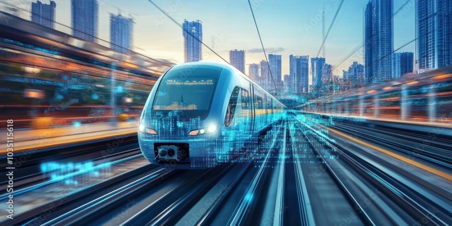
Technologies used in infrastructure monitoring are specified within some regulations, for example to inspect road and rail, specific vehicles are deployed with defined sensing technology to assess the health of the infrastructure using a variety of sensors which include radar, lidar, camera and accelerometers.
In addition to maintaining current infrastructure, new building projects such as HS2 and the Elizabeth Line experienced significant budget overruns with logistics and building efficiencies contributing to the high costs.
Operating the significant road, rail, air and maritime land based infra structure is a huge challenge which costs a lot of money. Road and Rail infrastructure managed and operated by local or national government departments are under pressure to reduce costs, improve efficiency and safety.
The challenge to maintain what is already in place is compounded by the addition of active travel and the addition of passenger support services. This creates a more complex environment to manage due to the interactions between the modes of transport and the changing use of the infrastructure.
Current practices for infrastructure monitoring and maintenance do not remove preventable safety issues, large maintenance repairs and crises from arising across transport infrastructure. The quality of repairs especially on roads is not regularly inspected creating variation in the life of localised road surfaces.
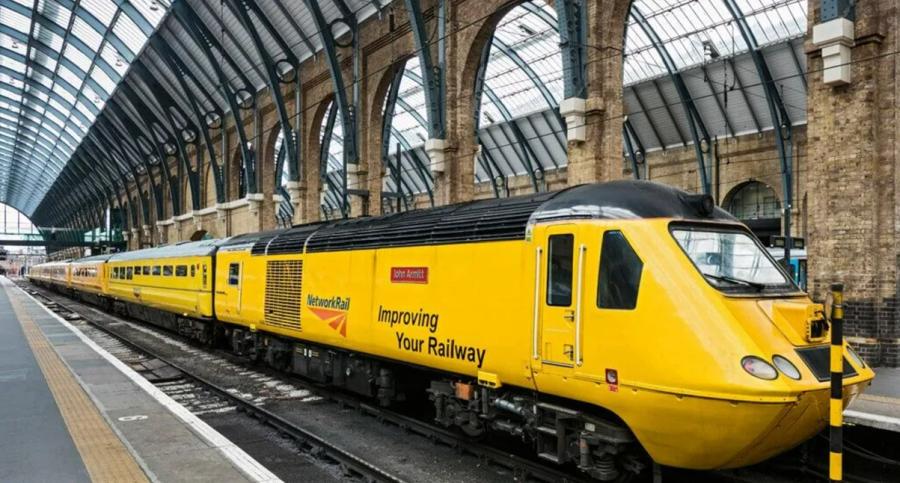
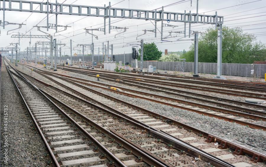
Network Rail - New Measurement Train (NMT) - Network Rail
What is the solution to the problem?
Sensing technology has developed quickly in the last few years and with the flexibility that 5G brings to carry high digital data loads and rapidly locate sensors means infrastructure monitoring is changing. Machine learning and artificial intelligence are the other key enablers for rapidly analysing the data produced to deliver improved insights.
Sensing and the data produced are conveyed over mobile networks to storage such as cloud services. This data can then be analysed using AI or other techniques to detect infrastructure anomalies and identify issues. The provision of accurate, regular data gathering rather than spaced out sampling of infrastructure, along with real time data analysis provides better insights to buildings, roads, rail, ports and airports.
Established digital sensors on infrastructure or located on specialist vehicles can provide detailed data on objects and markings, using various high density data sensors such as cameras, radar and lidar.
Weather, pollution, light and heat can be monitored using IoT sensors and structural integrity can be assessed using force, temperature, displacement, vibration, strain and electrochemical sensors.
Many new sensing technologies have also emerged, with recent examples highly relevant to infrastructure:
- Lidar (Laser imaging detection and ranging) - is used increasingly in infrastructure scanning as it produces accurate 3D images referred to as point clouds. This is more accurate than camera imaging for scanning complex shapes in detail and is being used to create the fine detailed maps used for driver assistance navigation maps and digitise buildings for example.
- Aerial monitoring via drones and satellite imagery provides remote monitoring capabilities, making it easier to assess hard-to-reach areas. This is particularly useful for large-scale infrastructure like railways and maritime ports.
- Fibre optic sensing includes Distributed Temperature Sensing (DTS), Distributed Temperature and Strain Sensing (DTSS) and Distributed Acoustic Sensing (DAS). These are types of optic sensing technologies which use the properties of light as it travels along a fibre to detect changes in temperature, strain and vibration. DAS can detect vibrations and pinpoint the source to a specific location along the length of the cable. This can be used on railways to detect rail line anomalies. This uses the trackside fibre optic cables already installed for comms and signalling to detect vibration when the train runs along the track. Impact when the wheel crosses joints and points create a vibration signature which can be monitored for change over time. The same technology can monitor geological phenomena (earth tremors and land movement), fatigue monitoring, thermal changes and leak detection as well as offering the opportunity to provide perimeter protection.
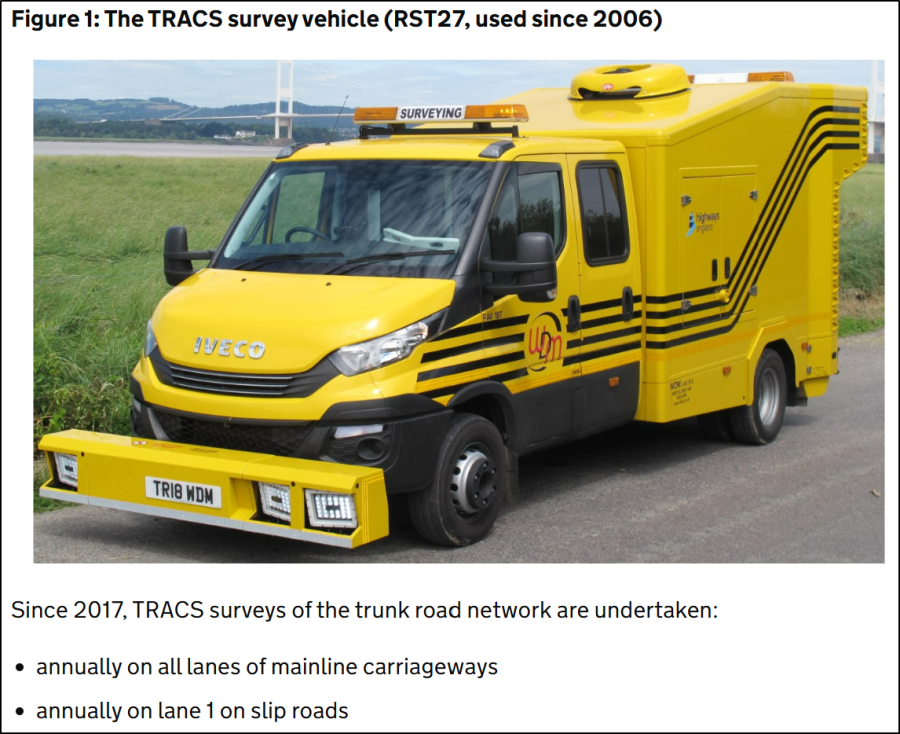
Mobile phones have been used recently as a low-cost way to scan road surfaces. This is a relatively simple repurposing of a developed technology to provide real time data using the inbuilt cameras and smart image recognition algorithms, useful to highways authorities in detecting road imperfections. Applying phones to vehicle fleets already covering the road network such as delivery or waste management vehicles, provides an ideal opportunity to collect the data required on a continuous basis.
Alternative scanning methods and products are being trialled across Road and Rail in particular. DfT is reviewing road condition monitoring and is introducing a new data standard that allows local authorities to choose technologies to suit their needs, as long as they align with the new standard. This shift is intended to encourage innovation and open the market to alternative technologies (Road condition data and technology review).
All the transport operators and infrastructure providers are looking for more efficient and effective ways to monitor their assets. A variety of very capable sensors, many of which are low cost, are transforming how infrastructure is monitored and maintained. The ability to mount these sensors quickly and transmit their data robustly using 5G communications provides flexibility and minimises installation effort and cost.
The availability of robust 5G communications across all 4 modes of transport infrastructure to enable the monitoring and services discussed in this document is covered by separate advisory toolkits for each mode of transport.
It is key to note that 5G upload speed and number of connections that can be supported on mobile networks are as important as download speeds for infrastructure monitoring. The volume of data transferred by camera, radar and lidar in real time is significant and the number of sensors being deployed is growing.
Recommendations and further discussion are focussed on 2 related opportunities:
Data sharing to enable efficient transport infrastructure monitoring and maintenance. Access to sensor data gives the transport providers as well as infrastructure operators opportunity to improve their services. This includes operators of vehicles, ships and planes that use the infrastructure. Data sharing provides an opportunity for innovation and rapid product improvement. Detailed work has already started to define standards for data to enable sharing in many areas of transport (see “intelligent traffic management” toolkit). There are European initiatives as well, such as SENSORIS where automotive, map providers and telecoms operators’ are collaborating (SENSORIS). Infrastructure monitoring data sharing across transport is a recommended discussion topic for DfT.
Wider monitoring services using shared data – Sharing sensing data, enabled by the previous recommendation, will enable insights across an integrated transport system and not just for bespoke and narrow applications. The opportunity is to create greater capability and better outcomes using a collaborative sensor set through the shared data. This opportunity requires cross modal thinking to define the goals and opportunities and it should include transport operators, infrastructure providers and passengers. This is a future opportunity and will assist in DfT’s future Integrated National Transport System (INTS) initiative.
Commercial model (Business Case)
The transport infrastructure assets in the UK are substantial. To put this in perspective each mode of transport, infrastructure is split into its key ingredients.
Roads (Road markings, Asset Management, Highway Infrastructure) :
The national highways teams in each country of UK manage the strategic road network and local authorities manage the majority of the network by length, which consists of:
- A public road network of 245,700 miles which includes road markings, cats-eyes, roadside parking, traffic calming measures and other features as well as the road surface itself.
- There are approximately 9,000 bridges on the strategic road network alone, in England.
- The UK has 100’s of road tunnels which includes large structures such as the Dartford Tunnel, which apart from structural assessments need to be checked for ventilation, lighting and emergency systems.
- There are an estimated 4.5 million road signs across the UK.
- There are approximately 6.5 million lamp posts in the UK (Shropshire.Gov) with ~95,000 in Birmingham as a city example.
- Buildings which include toll booths and service areas.
- Drainage systems which are integrated into the road network to prevent flooding.
Rail (Network Rail Limited Annual report and accounts 2023)
Network Rail is responsible for managing and maintaining the rail infrastructure with the Office of Rail and Road (ORR) who oversees its performance and adherence to standards. Rail infrastructure and inspections cover:
- 2,578 stations excluding heritage and TfL underground.
- 20,000 miles of track
- 64 intermodal rail terminals at docks and rail interchanges used for freight (Intermodal rail GB)
- 30,000 bridges, tunnels and viaducts.
- Depots and staff buildings.
- Drainage systems.
Airports (Regulations for air services in UK) :
Civil Aviation Authority (CAA) is responsible for regulating most aspects of aviation in the UK, including the safety and maintenance of airport infrastructure across airports. Statutory Inspections include:
- Runways and Taxiways: surface integrity and markings.
- Lighting Systems: lights which indicate edges, routes and parking on the runway and taxiways.
- Navigational Aids: equipment like Instrument Landing Systems (ILS) and radar systems.
- Buildings, Terminals, bridges, baggage systems: compliance with building regulations.
- Fire Safety Systems: maintenance of fire detection and suppression systems.
- Drainage systems.
Maritime Ports (MCA inspection - GOV.UK, Ship security - GOV.UK):
Maritime and Coastguard Agency (MCA) oversees the safety and security of maritime operations, including port infrastructure to ensure adherence to the Port Marine Safety Code (PMSC). Statutory Inspections include:
- Ships: compliance with international safety standards.
- Structural Inspections: docks, piers, and warehouses.
- Navigational Aids: lighthouses, buoys, and other aids to navigation.
- Environmental Compliance: waste management and pollution control.
- Emergency readiness: fire and rescue.
Statutory inspections are crucial for maintaining the safety, security, and efficiency of all the key infrastructure across the 4 modes of transport. Quantifying the opportunity for improvement involves trying to scale the tasks and issues common todays across each mode:
- Annual UK car damage was £1.7bn due to ROAD potholes, in the latest report Kwikfit.
- The costs to operate and maintain the ROADS in 23-24FY was ~£2.1bn by LA’s, with a further £8bn provided by DfT for road condition upgrade (National Audit Office report, July 2024). Key findings from this report included:
- There are currently significant gaps in DfT’s information on the condition of local roads, limiting its understanding of condition of the network.
- DfT does not consider the condition of roads or the factors that contribute to road deterioration when allocating funding to local authorities.
- DfT needs to plan now for how it will support local authorities to meet challenges on the road network, such as climate change and the introduction of self-driving vehicles.
- RAIL carries 1.45 bn passengers and 15.7 bn tonne/km of freight and track and power lines are checked by Network Rail staff monthly by manual inspection using a “condition-based inspection” where monitoring is focussed on more heavily utilised assets. More detailed inspections are carried out using a measurement fleet which includes the New Measurement Train (NMT). The NMT uses cameras and lasers plus other tech on a high-speed train. 115,000miles are covered with the measurement fleet with the busiest lines being inspected more often during the year. (NMT).
- Network RAIL net operating cost in 22/23FY was £7bn. Cost efficiencies are targetted for each control period which are 5 years each. Employee safety improvements, service improvements, and reduction of staff accidents are key PFI which include working practice and monitoring of infrastructure. (Network Rail Annual report 2023). Station platforms, trespass, vegetation, drainage and level crossings along the lines are amongst surveillance priorities.
- Commercial AIRPORTS in the UK which carry 226 million passengers and 2.0 million tonnes of cargo with significant buildings, baggage, cargo, runway and parking infrastructure (Compliance monitoring CAA) :
- Airport runways and infrastructure are inspected to ensure safety and compliance with aviation standards. The CAA oversees this with guidelines set out in the Aviation Security Regulations and other relevant frameworks.
- Runways are typically inspected daily, with additional checks after adverse weather or heavy traffic periods. These inspections include visual checks for debris, surface damage, and lighting functionality. Friction testing and structural evaluations take place monthly or annually depending on the airport.
- Commercial coastal MARITIME PORTS around the UK includes 400 non-cargo handling ports and 120 cargo handling ports. Annually inspections vary by the size of the port, operation and throughput of goods and people.
- Cranes, gantries and automated systems are inspected along with the quayside infrastructure, buildings and navigation equipment.
Smaller ports have a narrower infrastructure portfolio and will be inspected less often.
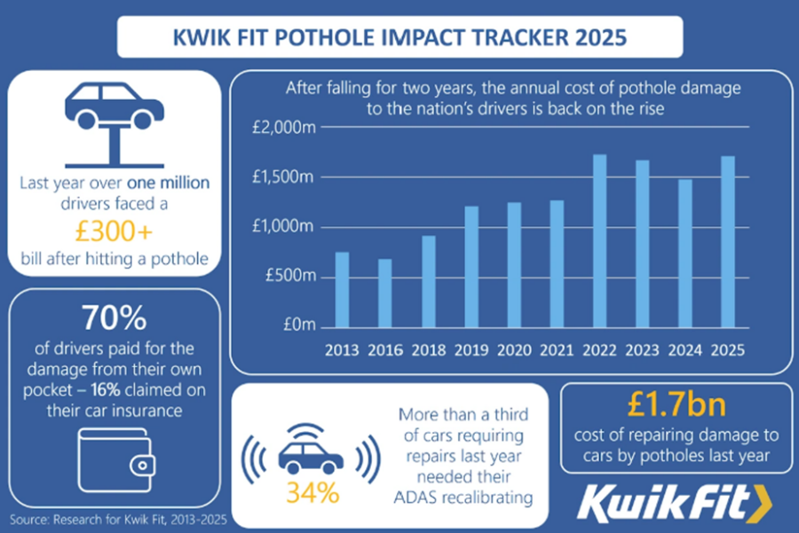
Image courtesy of Kwikfit
Benefits
More regular monitoring of transport infrastructure assets across road, rail, maritime ports and airports will improve the environment that the cars, HGV, airplanes, trains and ships operate. Issues will be caught before they become failures or crises. Infrastructure operators will be able to offer a more “proactive” rather than “reactive” approach to maintenance. This has significant benefits which include:
- Safety – reduce the number of accidents as hazards are reduced through effective maintenance and maintain regulatory compliance.
- Reliability of service - as less breakdowns and interruptions to service will be experienced.
- Efficiency – faster assessment at statutory inspection times as data is already available. Inspection systems can automate the inspection and recording against statutory requirements.
- Quality assurance – assessing infrastructure after repairs are completed to make sure it complies to specification.
- Cost reduction – reduce the severity and number of failures and operational downtime is reduced. Smaller repairs will be required which take less time and are more easily corrected.
- Passenger and employee satisfaction improvement - as transport services are more robust enabling focus on passenger support instead of troubleshooting when things unexpectedly go wrong.
Lessons Learnt
Products and services
Monitoring products can use rigidly mounted or mobile sensors to assess infrastructure and the environment around it. Sensors can more easily be relocated where 5G is used for data transfer rather than optical fibre.
Clustering infrastructure helps to see where types of sensors can have multiple uses. Using sensors for many purposes prevents duplication of sensor deployment and provides more efficient and cost-effective solutions.
If you’re ready to embark on a connectivity project, we can point you to the suppliers with expertise in your sector.