The use of drones in conjunction with high-capacity wireless connectivity provides a surveying tool capable of covering vast areas, whilst collecting large amounts of data and relaying this back to the farmer in real time. The improvement in yields and reduction in costs could generate $100 billion in additional value globally by 2030.
Agricultural crops are still widely monitored by agronomists, land managers and farmers. These time-consuming processes involve in-person visual inspection and collecting physical samples from the fields. If drones are used for agronomic purposes, the image data collected is currently stored to an onboard memory card that is downloaded later by the drone operator off-site, then uploaded to a proprietary system before being made available to the farmer / customer to provide the intelligence they need for informed decision making on the farm.
Enabling images to be sent directly from the drone, in the field (in flight) automatically for processing via high-capacity wireless networks enables the farmer to make timely decisions and reduce input usage / costs. Ultimately the target is an almost immediate application map that is available to the sprayer applying the fertiliser or pesticide.

What is the problem to be solved?
- The problem: Crops are still widely monitored by agronomists, land managers and farmers. These time-consuming processes involve visual inspection and collecting physical samples from the fields.
- The aim of the time saving by using high capacity wirelessly enabled drones is to allow the farmer to action decisions immediately after the drone flight has been completed. This is important as spraying windows can be short. Cool and humid conditions are the safest when spraying, with winds of no more than 2 to 4 miles an hour. These conditions often do not last long, and the key point is to avoid missing the available “weather window” to ensure effective crop protection.
- Commercial drone operating companies hire pilots to visit farms and complete drone flights. The drone pilot then returns home and uploads the images on their home Wi-Fi. These images are processed by the platform and then returned to farmers. By being able to upload data in the field, before leaving a farm, the pilot can free up more time to fly the drone and is able to get the images back to the farmer much more quickly, providing timely actionable intelligence.
- The process of operators uploading the images at home can take a long time. Indeed, it has been demonstrated that uploading a day’s worth of data could take several hours dependant on home broadband speeds. To improve on this, any connection in the field needs therefore to be high capacity and reliable.
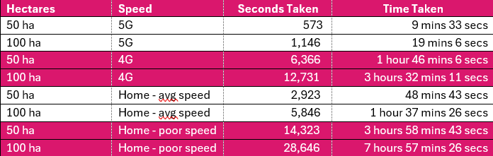
- During trials it has been possible to complete in-field wireless uploads where average upload speeds were 50mbps on 5G. Extrapolating this data, a field’s data could be uploaded in 1 minute 28 seconds and for a 50-hectare farm, this could be done in less than 10 minutes. On 4G, the equivalent could take 16 minutes per field or 1 hour 45 minutes for a 50-hectare farm.
- Field scanning on farms
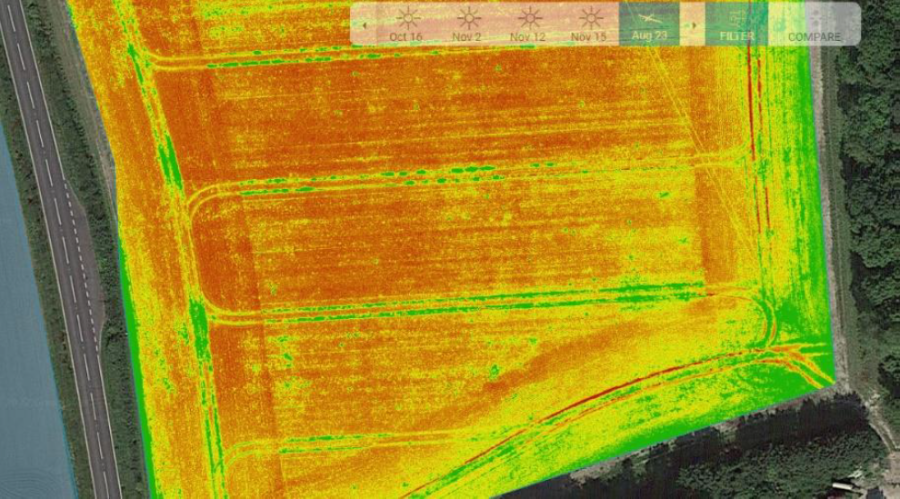
- A major use for 5G in agriculture is to transport images from cameras on a variety of vehicles back to the internet for processing. New businesses have formed in recent years who have begun offering this service on tractors, drones and robots (as well as from satellites). The ultimate purpose of these images is to enable precision agriculture: the images are used for identifying weeds, pests, disease and nutrient deficiencies in fields, to then be able to apply crop protection products and fertiliser where they will have the most impact, reducing inputs with consequential profitability and environmental benefits.
- Huge value exists in precision agriculture. As of March 2022, UK farmers spend on average £757/ha on herbicide and fertiliser applications to wheat. Estimates differ drastically on how much precision technologies could reduce use (and therefore cost) of fertiliser and pesticides. These range from 33% as the most conservative estimate to 95%. Taking the conservative estimate of 33% for a more realistic short to mid-term view, this would be an average saving of £249.80/ha which translates to very significant savings for a large estate.
- The value of 5G lies in ensuring that the data collected in these images can be transported to the machine applying crop protection products, completing the action efficiently (via any processing location). Currently, transporting the data between the two requires very manual inputs which makes the process slow and inefficient. Without 5G it often takes over 36 hours for data to be returned to the farmer. For such operations to work commercially into the future, 5G will be able to automate the data transfer aspect of the process by either a onetime upload once a job is complete, or ultimately automatically as the as the scanning is taking place.
- 5G connected drones can upload data over ten times more quickly than using 4G. It has also been found that 5G is easily able to continuously stream data from the drone into proprietary platforms for processing.
Field scanning can be commercially scaled once a modern high-capacity wireless connectivity solution is in place (initially in the form of a connectivity hotspot) and once there has been an improvement in the quality and cost of equipment which can understand and apply precise solutions. Such devices require good connectivity on the farm to allow upload from vehicles either live as they move, or once operation has been completed. These are not necessarily time sensitive tasks but will become so as machines become automated into the future and begin to pass data almost directly and in real time from machine to machine.
What is the solution to the problem?
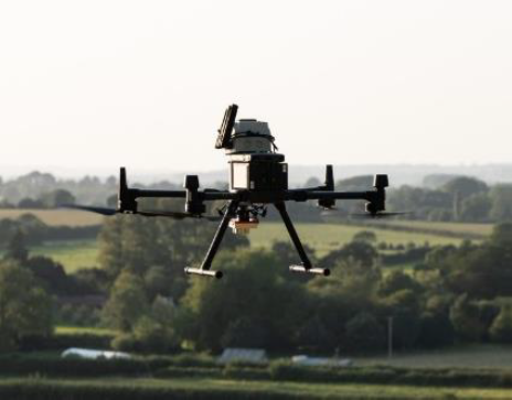
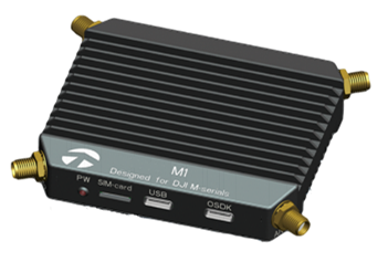
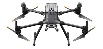
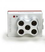
Tests were carried out using a Heliguy (DJI Matrice300) drone and a Micasense Red Edge MX camera fitted with a n77 5G modem, the transfer time between flying a field and receiving actionable data will be greatly reduced from the original 36 hours.
The modem unit used had a weight of 116g and power requirement of 4.6W, and was powered directly by the DJI M300 drone. The manufacturer cites video delay of c 300MS which is more than adequate for this task.
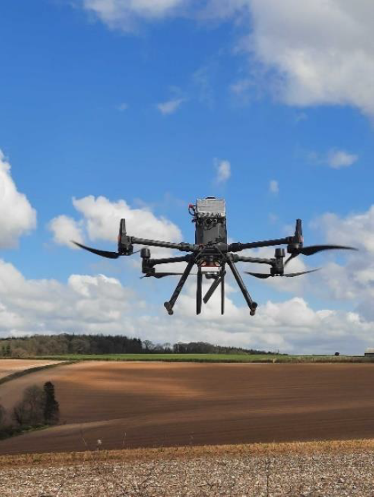
Battery packs are hot-swappable and in this test the team were able to survey around 9 ha on a single charge.
Tests showed the following upload times:
DJI Matrice300 drone, Micasense Red Edge MX camera and 5G modem
Commercial model (Business Case)
5G has the ability to provide effective connectivity in the field. Being able to upload data on a farm hotspot could save hours of time each day. Overall, it has been found that this system can make it 17 hours quicker to get results back to farmers from the drone. This provides two main points of value:
1) Convenience – For the farmer, getting images back much quicker after a drone flight does mean that they can get on with a task straight away rather than having to wait. This is especially significant as farmers rely on dry, still weather to be able to apply fertiliser and pesticides.
2) Reputation and operations – For drone-based agronomy providers, being able to deliver data quickly is key to developing a good working relationship with the farm business customer. Being able to get images uploaded direct in the field smooths operations both reducing the time spent on processing data and time manually handling data which reduces the operating costs for the service provider, which could provide a knock-on benefit to the farmer through cost reductions.
Value could be found from having an area on a farm to offload data quickly. 5G has the capacity that 4G does not to be able to do this effectively. The only question is whether there is any benefit of having 5G over a good WiFi connection.
In short, the cost of 5G implementation has been the main prohibitive factor. Spending £49,000 on a strong connection rather than a few hundred pounds has not up until now, made sense. Even though the additional coverage given by 5G over Wi-Fi is useful, the value brought has not previously matched the expense.
Benefits
Huge value exists in precision agriculture. As per March 2022, UK farmers spend on average £757/ha on herbicides and fertiliser application to wheat.
On a 200ha farm, this could equate to c. £151k total spend.
On a 1000ha estate, that could be c. £757k.
Estimates differ drastically on how much precision technologies could reduce use (and therefore cost) of fertiliser and chemicals. These range from 33% as the most conservative estimate up to 95% by some measures.
Taking the conservative estimate of 33% for a more realistic short to mid-term view, this would be an average saving of £249.80/ha. For the 1000ha estate, this represents a saving of £250k.
The environmental benefits of more precise fertiliser and pesticide placement should not be underestimated.
In the case of fertiliser, placing the amount that the plant is going to use results in significant reduction in the nitrification of watercourses, depending on local geography.
Accurate placement of herbicides and pesticides are similarly beneficial to the environment with reduced impact on non-target species and the environment.
It is important to note that the range of available herbicides, fungicides and pesticides is reducing as tighter environmental regulation means that many active ingredients that have been relied on for decades are removed, increasing the risk of crop loss to the farm. In some circumstances there are simply no effective active ingredients left to deal with particular problems. If precise placement can be demonstrated, and active ingredients are only being deposited where they are absolutely required, it may be that crop protection products that have been de-listed can be re-approved for use under specific conditions, reducing the risk of overall crop failure. This is one of the often-overlooked benefits of precision application. Total loss of a crop because of non-availability of appropriate active ingredients is becoming a reality and any technology which opens crop protection options to farmers and growers would be very welcome.
Lessons Learnt
Licensing of 5G spectrum requires modernisation to ensure it can enable rather than inhibit 5G roll-out in support of agri-tech applications. Regulation also needs to develop to be fit for purpose in the agriculture technology sphere to promote automation.
The process of applying for spectrum license is specialist and long-winded. Farming companies have had to sub-contract licence application to specialists as the process for applying for licences with Ofcom is complicated. This can take a lot of back and forth and in total, once the application had been submitted, the licences have taken over two months to be processed and approved. What’s more, the spectrum which was finally allocated by Ofcom was not compatible with the radio equipment and user equipment which meant further processing was required. This is not necessarily a failing of the process but a technicality that should be considered. All this adds time, cost and inconvenience to a process which, if smooth could allow for flexibility based on changing requirements in the field.
Airborne (drone) use is not permitted under the Shared Access Licence permissions. Ofcom rejected the use of drones on Shared Access Licences as radio frequency transmissions from a device operating at heights above the masts are difficult to manage. However, it was permitted to fly the drone and send data using an ’Innovation & Trial’ Licence as this short-term licence is easier for Ofcom to manage. This seems like a challenge that can be overcome and is clearly a barrier to the use of drones in agriculture and the roll out of 5G.
The provision of drone based agronomic services is growing, but providers are having to wrestle with significant connectivity challenges, and it is easy to overlook the impact of such technical challenges when developing business plans.
Established agronomy providers are beginning to offer such drone-based agronomy services and using established providers does mitigate the risk to the farm business somewhat.
However, change is disruptive, and it will be apparent to anyone looking at the sector that new approaches are creating opportunities for new business models.
If you’re ready to embark on a connectivity project, we can point you to the suppliers with expertise in your sector.